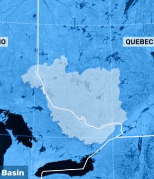
OTTAWA — Reviewing river conditions over the last few weeks, it is now apparent the peak levels observed between April 8 and April 15 constitute the first peak of the Ottawa River.
This first peak typically occurs as the local tributaries in the unregulated portion of the basin lose the bulk of their snow cover, which has now happened. A typical pattern for the spring freshet on the Ottawa river sees a second peak, as snowmelt runoff water from the northern portion of the basin flows down the main stem of the river.
Current Snowpack Conditions
There is no snow remaining in the southern portion of the basin and in the valley bottoms along the main stem of the river. The snow water content, or the quantity of water held in the snowpack, in mid-April was above average. Between 20 and 100 cm of snow remained at that time at higher altitude in the headwater areas of local tributaries such as the Rouge, Coulonge, Dumoine and Petawawa rivers. In the northern portion of the basin, below normal temperatures over the last two weeks have considerably slowed down the melt and a snow cover between 100 and 200 cm deep remains on the ground. There was however significantly less snow across the basin in mid-April compared to 2019.
Reservoir Regulation Strategy & Current Level, Flow Conditions
The reservoirs the furthest away from the main stem of the Ottawa River have been storing most of the spring runoff flowing into them, as is done every year. The storage volume of these reservoirs is large compared to the average runoff in these areas and storage capacity is currently not a concern. For most other reservoirs, the operational strategy has been to release as much runoff to downstream areas as possible to retain the bulk of the storage capacity for flood protection if required later.
The operators of the Poisson Blanc and Baskatong reservoirs did decrease discharges prior to the heavy rainfall event of April 13, in an effort to prevent the levels in the lower Ottawa River exceeding minor flood levels. In mid-April there was overall as much storage capacity left in the reservoirs as at the same time last year. With less northern snowpack remaining compared to last year and southern snowmelt completed, the principal reservoirs are likely to be able to contain the runoff from the northern portion of the basin.
Current levels and flows have been steadily decreasing along the main stem of the river in most locations over the last week as cooler than normal temperatures slowed the melt of the remaining snow in local tributaries.
Longer-term Overview
In the coming weeks, members of the Committee will be balancing the decreasing risk of experiencing downstream flooding with the increasing risk of not filling up reservoirs to meet navigational or recreational constraints.
Could levels rise again and form a distinct second peak as we have seen in previous years? If weather conditions over the next few weeks remain close to normal, a second peak, if it occurs, would not exceed levels already observed this freshet. The general trend for longer term conditions is for levels along the main stem of the river to continue to decrease at a rate that will depend on temperatures and precipitation.
All factors known at this time continue to indicate a spring freshet 2020 without excessive flooding. However, the Committee continues to closely monitor conditions. This report provides a summary of current mid spring Ottawa River basin conditions and expectations for river flows and levels over the remainder of the freshet. The Ottawa River Regulating Committee continues to monitor the Ottawa River basin closely as the spring freshet progresses. The Ottawa River Regulating Committee will also continue to monitor basin conditions and report conditions to residents on its website at www.ottawariver.ca.


![Kenopic/Smith Auction [Paid Ad]](https://whitewaternews.ca/wp-content/uploads/2018/10/advertising-100x75.jpeg)

