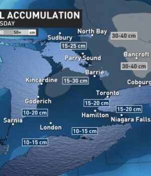
ONTARIO — The potent snowstorm will continue bringing significant snowfall across Ontario and the following snow squall event could cause some local accumulations to exceed 50 cm.
Snowfall will intensify across southern Ontario until the pre-dawn hours of Thursday and will then peak through the morning hours for the Ottawa region. The storm that is creating challenging late winter conditions has prompted snowfall warnings across the Greater Toronto Area and winter storm warnings for parts of eastern Ontario including the City of Ottawa. After this system departs the region, a prolonged snow squall event will bring another round of heavy snow and some could see totals exceed 50 cm.
Heavier snowfall amounts are expected for parts of eastern Ontario, Ottawa included, as the snow advances northeastward. Winter storm warnings are currently in effect, with significant impact expected on commute times for Thursday.
Ottawa Mayor Jim Watson has recommended that residents work from home on Thursday to reduce the number of vehicles on the roads, as the significant snowfall will be hazardous for motorists.
Between 20-40 cm could fall into Thursday and there is even the chance for some areas near the Quebec border to exceed 40 cm by the evening.
“Consider postponing non-essential travel until conditions improve,” warns Environment Canada. “Rapidly accumulating snow could make travel difficult over some locations.”


![Kenopic/Smith Auction [Paid Ad]](https://whitewaternews.ca/wp-content/uploads/2018/10/advertising-100x75.jpeg)

