

The mode of travel of the aboriginal people in present-day Whitewater Region was by both water and land. Water travel was by birchbark or dug-out canoe while land travel was by walking or running. Animals or a group of people may have been used to pull heavy loads on a travois. Aboriginal trails, used for thousands of years, were the first “roads” that explorers, fur traders and the eventual first settlers used to move themselves and goods from one location to another.
The first boundary line for the Township of Westmeath was surveyed in 1825 by Owen Gwinn. The boundary between Ross and Westmeath townships was surveyed by John McNaughton in 1831. McNaughton then surveyed the remainder of Westmeath township into concessions, lots and road allowances in 1833. Many of the aboriginal trails became roads in conjunction with the surveyed roads. The accompanying map shows the aboriginal trails as well as surveyed roads.
Beginning in 1835, the first settlers arrived in the region as a result of government incentives to have the district settled. In settling Westmeath and Ross townships there was initially only one way to access the region. This was by travelling up the Ottawa River from Ottawa by steamboat to the present day community of Portage du Fort, Quebec.
From Portage du Fort, a settler would walk or travel on horseback to the inner parts of the region on the aboriginal trails. The trails were too narrow and uncertain for wheeled vehicles. As time went on, two-wheeled carts became popular and were still in use by the early 1860s as the roads were still too rough for any means of locomotion except horses. As roads were improved, stagecoaches eventually came into use on some district roads.
One option for a settler was to follow an aboriginal trail from Portage du Fort along or through a series of small lakes to the larger Muskrat Lake. Settlers then travelled overland from the head of the lake on an aboriginal trail (now called Indian Road) to the Ottawa River and then proceeded up or down the Ottawa. This was one of the routes used by Samuel de Champlain in 1613.
Another option was to paddle a canoe beyond Portage du Fort and continue up the Ottawa. This route was more difficult due to the rapids. However, it was the main route for the fur traders a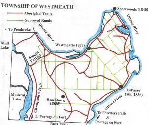 nd explorers.
Portage du Fort was the lifeline of goods arriving from other parts of the country. Eventually general stores were built and shipments arrived periodically as did mail on horseback. For several years settlers travelled back to Portage du Fort on horseback to pick up goods. Later on, steamboats were inaugurated at nearby Bryson, Quebec and headed on up the Ottawa.
Alternatively, the means of transportation changed when Jason Gould established the Union Forwarding Line. The Line included boat service on Muskrat Lake and a stage coach route over the trail used by Champlain. Leaving the Ottawa River at Snow Rapids below Portage du Fort, the Line proceeded to Cobden and then on to the west end of Muskrat Lake.
In 1850 Gould used two flat-bottomed rowboats on his Line on Muskrat Lake. By the next year these were replaced by “The Muskrat”. It consisted of two rowboats side by side, catamaran fashion, decking them over, placing an engine and boiler on deck and a paddle wheel at the stern. There was a second deck overhead.
Business expanded to such an extent that Gould built a second larger steamboat known as “The NorthStar.” In operation by 1853, Captain Daniel Cowley was in charge. During the high water periods, boats were able to travel up the Muskrat River to Croskery’s Landing within 2-1/2 miles of Pembroke. If water levels were low, the boats only reached Devon’s Wharf at Graham’s Station or the location later designated Meath. Ox-carts were utilized to convey passengers and freight from these points to Pembroke and were later replaced by horses and wagons.
The first road into the region from Ottawa was to Portage du Fort, then through Foresters Falls and Beachburg and on to Pembroke. This original road is still evident in the current Government Road which connects Foresters Falls and Beachburg. In 1846, the Federal Government conducted a survey to open a new road from Ottawa to Pembroke through Cobden. Government funds were initially unavailable but finally by 1855 the new road through Cobden was opened to Pembroke. Had this newer road not been constructed, Foresters Falls and Beachburg would today be on the Trans Canada Highway.


